Archives

All posts for the month July, 2016

So today I rode with Luca.  He is a St. John’s shredder, but before he lived here, he used to be living in Burlington and Hamilton.  So it’s a small world, we both know some of the same people and same trails.

We started off on the Sub Net trail.  (There used to be an actual anti-submarine net beside the trail back-in-the-day, the submarine net coming from even-more-way-back-in-the-day.  The net is gone now.  The trail loops past a bunch of underground military bunkers, most of which have cool graffiti on them now.)

DSCF6936

Here’s one of me, courtesy of Luca.

S0026948

Then we hit Oceanside trail.

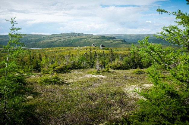
The mellow start to Oceanside.  I managed to flat out on the downhill, but it was this view that I got to look at while I pumped up a new tube.  Sa-weet.

S0076973


This Oceanside descent eroded away, but there’s still a good way down (if you’re as skilled as Luca).  This is at least a 6-8 footer, with a fairly bad run-in and a flattish landing.  Luca rode it like a pro.

Untitled_Panorama1


My GPS showed a bunch of trails that were fun to explore.  This was at the bottom of a downhill on a newer section at Subnet.  This was Luca’s first time on this section but he made it look like old hat.

S0146988


Conditions were perfectly tacky.

S0096977


We also noticed some gap jumps.  Next time?

DSCF6940


Ride data below.

Continue Reading

I had a great ride in St.John’s today, covering a bunch of the trails that I rode when I first started to ride a bike.  Last time I was in St.John’s was 30 years ago.  A lot has changed, but also, a lot hasn’t.

You might want to check out Gazeebow Unit’s rap song, “Trikes & Bikes”.  (Yes, I did venture into Airport Heights.  PLUS, I saw the ACTUAL gazebo!)


Here was my ride loop:

Total climbing: 1119 m
Total time: 02:56:35
Download file: baby-luke.gpx

The first stop after the ferry crossing was the town of St. Anthony.  We quickly found a Mary Brown’s and ate Taters.  Trip to Newfoundland now made official.


A dude in the mall excitedly told us about the iceberg and asked if we had been to see it yet.  So we went to see it.

We went out to the end of the harbour.

DSCF6851

There were actually several icebergs at the mouth of the harbour.  Here’s one you can see with a view looking back at town:

DSCF6853

The biggest one conveniently parked itself right in front of a viewing platform.  And there was a trail right to the best view — already there.

DSCF6855

DSCF6860


From beside the iceberg, there was a nice view of the lighthouse, looking north towards Greenland…


DSCF6864

Plus some other tidepool stuff…

DSCF6865

DSCF6867

From there, we drove out to Lance-Aux-Meadows to check out the viking settlement.

Leif Eriksen’s house.  Just a mound now:

DSCF6873

A replica sod house built by Parks.


DSCF6877

DSCF6886


Driving south, we saw a wicked fog bank building along the coast.

DSCF6890

Shadow of the van, bike rack visible.

DSCF6893

West Coast of Newfoundland, a bit north of Gros Morne, evening light.

DSCF6896

The arches.

DSCF6905

DSCF6906

DSCF6909

DSCF6915

DSCF6918

DSCF6922

We attempted this campsite, but it was a bit too buggy.  The lighting was good enough for a quick pic.

DSCF6794


The next day we reached the Churchill River.  Not much flow.

DSCF6797

There was the remnant of an old cable car system.  This must have been used before the bridge.  It was a repurposed crane, with chunks of the vehicle installed into a small building.

DSCF6798

DSCF6800

DSCF6801

DSCF6803


Here you can see the girders of the bridge.

DSCF6804

And a view from the bridge of the cable-car.  You can see the cables pass up to a tall spar (similar to what a quarry or logging operation would use).

DSCF6806

The bridge is quite a few stories above the waterway.

DSCF6808

The original river flow must have been impressive before the water was diverted.


DSCF6809

DSCF6811

Happy Valley – Goose Bay:

DSCF6813

DSCF6816

DSCF6819

The scenery mutated as we headed south.

DSCF6821

The pavement disappeared and we were chased by a dust cloud.  This went on for about 500km.  Rough road conditions, and tons of bugs.

DSCF6825

Finally reached the coast.

DSCF6831

Our first view of an iceberg didn’t take very long.

DSCF6832

And now we reached the border with Québec again.

DSCF6834

DSCF6835

Last view of Labrador!

DSCF6839

Lucy, the van and an iceberg in the middle.

DSCF6845

The Fire Lake mine:

DSCF6762

DSCF6767

Mont-Wright mine.

Mont-Wright does not exist any more.

See?

DSCF6769

DSCF6770

DSCF6775

Check out this one tailings pile.  (There were dozens of these, this isn’t even the largest) For scale:

DSCF6778

Fermont is an interesting mining town.

It’s a company town.  It’s so cold and windy, that the town is built as a huge structure that doubles as a windbreak.  It’s 1.3km long.  Here’s a film.

It’s an arcology!

DSCF6781

DSCF6784

After Baie Comeau, we turned north on Route 389.

First roadside attraction was the Manic-2 power dam site.

DSCF6697

Here’s a turbine:

DSCF6691


For the rest of the description, we turn to Wikipedia:

The Québec North Shore Company and Hydro-Québec completed portions from Route 389 to the Manic 5 hydroelectric project site (km 212), now known as the Daniel-Johnson Dam.

DSCF6699

DSCF6701

DSCF6700

DSCF6703

DSCF6705

DSCF6706

From km 212, the highway follows a path traditionally used by aboriginal people and explorers, with access to the Hart Jaune Hydroelectric Complex at km 390.

DSCF6732

The town of Gagnon, now torn down, was at km 394.

DSCF6751

Starting at km 482, the “Fire Lake Mine Road” section was built by unemployed workers during a labour dispute, influenced by the presence of the railway owned by the Québec Cartier Mining Company. This section of paved road is notoriously known as “the trail.”

DSCF6724

From km 482 to the provincial border at km 570 (354 miles from Baie-Comeau), the road is an accident-prone section notorious for its poor surface and sharp curves (the joke being you can see your own taillights).[citation needed] Local citizens in adjacent Labrador have been urging realignment of this road, a vital work if it were to be the routing to a fixed link to Newfoundland.

DSCF6759


One of the coolest things ever, ever seen, was the Manicouagan Crater.  The impact was from 213 MYA (at time of publication).  The entire northern region has amazing amounts of Impactite.  It’s basically a bunch of glass-like rock and glitter, everywhere.

DSCF6716

We crossed a few parallels today.

DSCF6710

A lot of dusty, bad, mountainous gravel roads.  Much better roads than the Alaska Highway, however.  So far, it’s a piece of cake in terms of road conditions.  The roads are ridiculously steep though.  We saw one stalled truck rolling backwards down a steep, loose grade, things got a bit sketchy as he barrelled backwards right at us.

DSCF6709

DSCF6711

DSCF6712

This was our first wilderness campsite of the trip.  The air smelled amazing and the mosquitos and blackflies weren’t even that bad.

DSCF6745

There was muskeg everywhere this morning.

DSCF6747

And tadpoles!

DSCF6749

Ah, finally.  A night spent in a Wal*Mart parking lot.  This one was somewhere near Granby, QC.  There were about 1/2 dozen other campers.

DSCF6656

DSCF6657

The next morning we rolled eastwards to Charlevoix.  They seem to have a big cycling race scene there.

Also, the dogs are happy.

DSCF6660


Sometimes the highway got a little soggy…

DSCF6666

DSCF6668


Fjords are cool.  That is all.

DSCF6676

DSCF6684


Just as we reached Ottawa, so did a huge weather front.

DSCF6644

Crazy cloud formations

DSCF6647

Lucy’s family took Lucy and I for a quick bike ride around the neighbourhood.  We ended up seeing a huge smoke cloud emanating from the subdivision around mid-day and calling 911-fire.

Here’s what we discovered the next morning.

DSCF6654

DSCF6655


So here’s the weird thing.  Another house just burned down in the same neighbourhood.  Hope it isn’t an arsonist.